KAIST
BREAKTHROUGHS
Research Webzine of the KAIST College of Engineering since 2014
Spring 2025 Vol. 24Crowd-sourced cognitive mapping: A new way of displaying people’s cognitive perception of urban space
Crowd-sourced cognitive mapping:
A new way of displaying people’s cognitive perception of urban space
A crowd-sourced cognitive map – a novel method to create a visual representation of urban identity – was developed. By utilizing cognitive mapping and georeferenced text data, the new visualization combines the advantages of both conventional and state-of-the art research techniques to successfully depict the collective identity of places in a single image.
Article | Fall 2019
Discourse on place identity has remained a vital topic in urban studies for the economic and social benefits it brings to the sustainable development of cities. Unfortunately, cities are criticized for losing their identity in the worldwide trend of standardization in urban morphology resulting from economic and cultural globalization. In this context, the pursuit of place identity has become increasingly important in modern mass-produced landscapes for both the interaction among people and between people and the surrounding environment.
Several research techniques have been used to assess place identity. In the days when collecting data on a massive scale was infeasible, qualitative approaches including survey, interview, participant observation, and cognitive maps, were key sources to obtain information about how people perceived their cities. Such conventional techniques, however, are prone to subjectivity, leaving concerns about the reliability of the results. Today, in the era of big data, individuals act as sociocultural sensors that constantly generate data on urban form and function. The crowd-sourcing of data has allowed the interpretation of collective identity of place and the spatial perception of people to address the subjectivity problem in traditional research methods.
Mr. JANG Kee Moon and Prof. KIM Youngchul in the KAIST Urban Design Lab of the Department of Civil and Environmental Engineering at the Korea Advanced Institute of Science and Technology (KAIST) developed a new way of displaying people’s cognitive perception of urban space – a crowd-sourced cognitive map – by combining the advantages of both conventional and state-of-the-art research techniques. Based on the premise that texts deliver user perception more directly than other forms of data (photos, geo-location, etc.), the research team constructed a dataset of hashtags in social media contents, from which identity-related meanings are extracted to validate the potential of textual data in discovering place identity. Subsequently, collected data was processed into a visual representation to substitute symbols and written text in conventional cognitive maps.
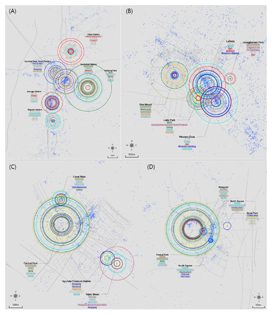
The research team selected four case cities located in Seoul metropolitan area to test the validity of the developed method: Bundang, Dongtan, Ilsan, and Songdo. The resulting crowd-sourced cognitive maps of four cases reveal differences among locations, such as frequency distribution and category composition of text elements (Figure 1). This method indicates that while several locations equally participate in the formation of collective urban identity, they are perceived as separate places in terms of available activities, induced emotions, or visiting purposes.
The key finding of this study was that crowd-sourced cognitive map carries implications for the urban identity formation process, especially in newly developed cities in Korea. The maps of Bundang and Ilsan (Figures 1A and B, respectively), show that visuals representing each location’s place identity are displayed in a nearly even distribution in terms of their size. Such a pattern implies that place identity formation has been completed in multiple locations in new towns that are entering their fully developed stage. In contrast, a clear distinction is observed between locations in Songdo and Dongtan (Figures 1C and D, respectively). The prevalence of green open spaces over other functions in cities that are in the initial stage of development conforms to the history of new-town development in Korea, where cities have made slow progress in becoming self-contained with sufficient urban infrastructure, but rather developed into commuter towns. Therefore, interpreting the crowd-sourced cognitive map suggested in this study can provide indications of the current state of urban identity formation.
The researchers’ findings opened the possibility for the use of social media text data in capturing the identity of cities and suggested a graphical representation through which people could understand the image of the city. This research was published on June 20, 2019 in PLoS ONE with the title of “Crowd-sourced cognitive mapping: A new way of displaying people’s cognitive perception of urban space” (DOI 10.1371/journal.pone.0218590).
Most Popular

When and why do graph neural networks become powerful?
Read more
Smart Warnings: LLM-enabled personalized driver assistance
Read more
Extending the lifespan of next-generation lithium metal batteries with water
Read more
Professor Ki-Uk Kyung’s research team develops soft shape-morphing actuator capable of rapid 3D transformations
Read more
Oxynizer: Non-electric oxygen generator for developing countries
Read more
