KAIST
BREAKTHROUGHS
Research Webzine of the KAIST College of Engineering since 2014
Spring 2025 Vol. 24Optimal levee installation planning for highway infrastructure protection against sea level rise
Optimal levee installation planning for highway infrastructure protection against sea level rise
A simulation-based levee installation optimization model is proposed to minimize highway network delays due to inundations. The findings are applied to a real-world network in California for a 0.5 m sea level rise, and it is found that there are critical shorelines to protect with priority.
Article | Fall 2019
Climate change has been a global concern in recent decades, and it has already been shown to impact natural systems while leading to increased frequency and intensity of storms, flooding, and other extreme weather phenomena. The Intergovernmental Panel on Climate Change reports highlights that coastal flooding due to sea level rise and storms is among the most serious effects of climate change. The impacts of sea level rise can be threatening for coastal infrastructure; thus, so preventive actions is vital. An example is the 1996 flood in the Boston metropolitan area that is evaluated to have cost around $70 million in property damage.
Transportation network interactions in cases of inundation can lead to severe disruptions that cause capacity and accessibility reduction and thus considerable delays. A primary cause of such delays is congestion feedback, as congestion occurring due to an inundated link or a link that becomes isolated through inundation of one of its nodes can lead to delays in other parts of the network, due to queue spillback or traffic rerouting.
A research team (http://riser.berkeley.edu/) involving KAIST Assistant Professor Jinwoo Lee proposes a decision tool to support transportation infrastructure protection planning against sea level rise. A simulation based bi-level model is designed to minimize delays occurring in a highway system under inundation. The model considers budget constraints, hydrodynamic interactions within the shoreline, as well as traffic dynamics in the network.
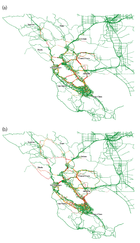
The case study focuses on San Francisco Bay area. Due to the projected traffic demand increase in the Bay Front Counties from 2010 to 2054, the average travel time per trip during the peak hour also increases by 52% from 26 minutes to 40 minutes, even with no inundation (see Figure 1(a)). However, a 0.5 meter sea level rise in the San Francisco Bay Area is expected to be reached in 2054 and may increase the average highway users’ travel time by up to 37% (or by 14.6 minutes) depending on the shoreline protection plan. In other words, if the whole shoreline is unprotected, the average travel time during the peak hour will be 54 minutes per trip, while with complete protection, it will be 40 minutes (refer to Figure 1(b)).
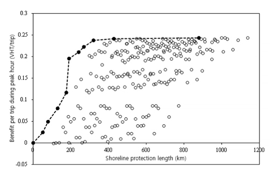
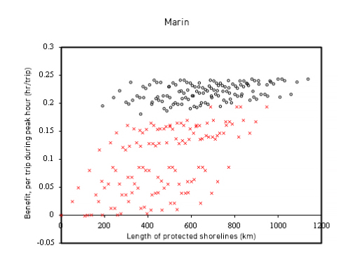
The tradeoffs between users’ travel time benefits and total lengths of protected shorelines are investigated for the possible combinations of a levee installation plan, which are represented in Figure 2. The results show that the optimal strategies vary according to the available budget, and that there are relatively critical shorelines to protect, such as the shoreline of Marin (see Figure 3), in order to reduce the traffic disruptions.
It is anticipated that the present research will provide a general framework for transportation infrastructure protection planning against sea level rises so that policymakers can benefit from the results to prioritize candidate sites to protect transportation networks against flooding.
The present work was published in Transportation Research Part D: Transport and Environment
(doi: 10.1016/j.trd.2019.02.002) on February 21, 2019 and is available online
(https://www.sciencedirect.com/science/article/pii/S1361920918304152).
For further information : https://www.sciencedirect.com/science/article/pii/S0191261518306477
Most Popular

When and why do graph neural networks become powerful?
Read more
Smart Warnings: LLM-enabled personalized driver assistance
Read more
Extending the lifespan of next-generation lithium metal batteries with water
Read more
Professor Ki-Uk Kyung’s research team develops soft shape-morphing actuator capable of rapid 3D transformations
Read more
Oxynizer: Non-electric oxygen generator for developing countries
Read more


